


2020-02-04_08h37m28_Les Crets

gerardmicheline
User
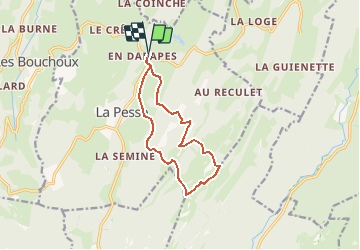

Length
11 km

Max alt
1435 m

Uphill gradient
434 m
Km-Effort
16.8 km

Min alt
1161 m

Downhill gradient
437 m
Boucle
Yes
Creation date :
2020-02-04 07:37:28.441
Updated on :
2020-04-12 13:14:10.311
3h29
Difficulty : Difficult

FREE GPS app for hiking
 SityTrail
IGN / Geographical institutes
SityTrail Plus
The world is yours!
About
Trail Walking of 11 km to be discovered at Bourgogne-Franche-Comté, Jura, La Pesse. This trail is proposed by gerardmicheline.
Positioning
Country:
France
Region :
Bourgogne-Franche-Comté
Department/Province :
Jura
Municipality :
La Pesse
Location:
Unknown
Start:(Dec)
Start:(UTM)
719993 ; 5131124 (31T) N.
Comments